History of Mira Road: From Rural Villages to a Mumbai Suburb
Discover the history of Mira Road and Mira Bhayandar, from their village roots and agricultural landscape to municipal development and modern urban growth.
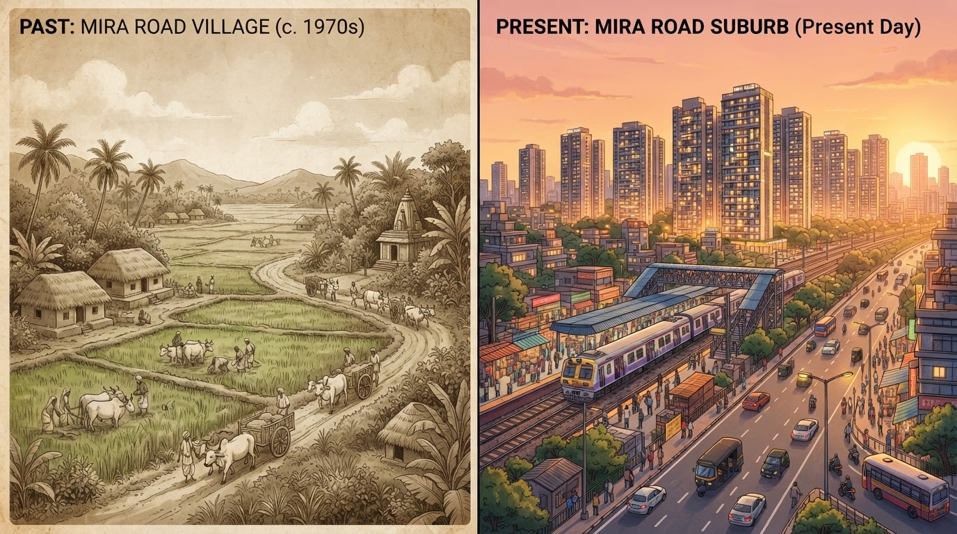
Mira Road is now known for its residential societies, busy roads, railway connectivity, shopping centres and growing neighbourhoods. Thousands of people live, work, study and run businesses across Mira Road and the neighbouring areas of Mira Bhayandar. But the area did not always look like the urban landscape residents see today. The story of Mira Road is closely connected to the older villages of the region, the development of municipal administration, its proximity to Mumbai and the expansion of housing and transport infrastructure. Understanding this history helps explain how Mira Road became an important residential part of the Mumbai Metropolitan Region — and why its older settlements, surrounding natural landscape and newer developments continue to shape its identity.
1. Where is Mira Road, and what makes its location important?
Mira Road is part of Mira Bhayandar, an urban area in Maharashtra's Thane district, immediately north of Greater Mumbai. Its location has played an important role in its development. The wider Mira Bhayandar region is connected to Mumbai by suburban railway and road networks, while the surrounding geography includes hills, coastal areas, creeks and environmentally sensitive landscapes.
The Ministry of Housing and Urban Affairs' Comprehensive Mobility Plan for Mira Bhayandar identifies the area as part of the Mumbai Metropolitan Region and describes its growth as closely connected to its accessibility to Mumbai.
This location created an important opportunity: people who needed access to Mumbai could consider living beyond the more expensive and densely developed parts of the city. However, Mira Road's history is not simply a story of buildings expanding northwards. It is also the history of a collection of villages and settlements gradually becoming part of a larger urban area.
2. Before modern urban development: a landscape of villages
Before the expansion of modern residential development, the wider Mira Bhayandar region included village settlements and land used for activities such as agriculture, fishing and salt cultivation. The municipal corporation's planning documents describe the area's earlier rural character and the role of village-level administration before the creation of a unified municipal body.
Agriculture, including rice cultivation, is mentioned in historical accounts of the region. Fishing and salt-related activities also formed part of the area's wider economic landscape.
It is important to distinguish between the history of Mira Road itself and that of the wider Mira Bhayandar region. The latter includes several older settlements, including coastal villages, whose histories should not be treated as identical.
The modern residential neighbourhoods residents recognise today developed over time. They grew alongside older settlements rather than appearing as one planned city at a single moment.
Why this rural history matters
The earlier village landscape helps explain why the region has varied neighbourhoods, settlement patterns and land uses. It also reminds us that the area's identity extends beyond modern housing societies and commercial roads. Traditional communities and older settlements remain an important part of the wider region. Detailed histories of individual villages would require additional archival research, including local land records, historical maps, gazetteers and oral histories from residents.
3. How Mira Bhayandar's municipal administration began
One of the most important milestones in the area's modern history was the establishment of the Mira Bhayandar municipal administration. According to the official Mira Bhayandar Municipal Corporation website, the municipality was established on 12 June 1985 through the merger of five village panchayats. The municipal body's boundaries were subsequently extended to include additional settlements. The official municipal history records further inclusion of villages in January 1990.
The establishment of the municipality on 12 June 1985 represents a significant milestone in Mira Bhayandar's transition from a group of village-governed settlements towards a more unified urban administration.
This was an important change in how the area was administered. Instead of relying exclusively on separate village-level institutions, the expanding urban region increasingly required coordinated arrangements for civic infrastructure and public services. These responsibilities include matters such as roads, water supply, drainage, sanitation, public health and urban planning.
Why 1985 was an important milestone
A growing settlement needs more than individual buildings and roads. It also needs a system for coordinating services across neighbourhoods. Municipal administration creates a framework for planning and managing public infrastructure across a wider territory. The establishment of the municipality therefore represents a significant milestone in Mira Bhayandar's transition from a group of village-governed settlements towards a more unified urban administration.
4. The expansion of municipal boundaries in 1990
The next major administrative milestone came in 1990, when additional villages were brought into the municipality. The MBMC's official history records the inclusion of four additional village panchayats on 23 January 1990. Other municipal planning documents describe a wider boundary-extension process involving additional settlements.
The wording and enumeration of the included villages differ across municipal documents, so an exact historical village-by-village account should be checked against the relevant government notifications.
The broader significance, however, is clear: the municipal area grew beyond its original boundaries.
What this meant for urban development
As more settlements became part of the municipal area, planning for roads, drainage, water supply and other public services became more complex. Different settlements had different existing conditions, and their integration into a common administrative structure required coordination. The larger area also provided the framework within which later residential and commercial development could expand. This period is best understood as an important stage in the institutional growth of Mira Bhayandar, rather than as a single event that transformed every neighbourhood overnight.
5. From municipality to municipal corporation in 2002
Another major milestone occurred on 28 February 2002, when Mira Bhayandar's municipality was upgraded to a municipal corporation, according to MBMC's official history. This change reflected the area's growing urban character and the need for a larger municipal administration. A municipal corporation is responsible for coordinating a broad range of local services and urban development functions under the applicable legal framework. These include urban planning, public works, waste management, water supply, drainage, public health and other civic responsibilities.
Many of the everyday issues residents discuss — road repairs, water interruptions, building permissions, waste collection and public infrastructure — fall within the broader system of municipal administration. The corporation's establishment created an important institutional foundation for managing these services across Mira Bhayandar.
It also marked a shift in the area's administrative identity: Mira Road and neighbouring settlements were increasingly part of a larger urban system connected to Mumbai's metropolitan growth.
6. How Mira Road grew as a residential suburb
Mira Road's residential expansion is closely connected to its proximity to Mumbai and the wider growth of the metropolitan region. As housing demand increased, land on the metropolitan periphery became increasingly important for residential development. The municipal corporation's development-planning documents describe Mira Bhayandar as a rapidly urbanising area, with its location near Mumbai contributing to residential growth.
Over time, agricultural and village landscapes in parts of the region were replaced or surrounded by housing, roads, shops and other urban uses. Residential development did not happen uniformly. Different localities grew at different times and under different land-use conditions.
The role of transport connectivity
Transport access is an important factor in residential location decisions. For people commuting to Mumbai, railway and road connections can influence where they choose to live. A suburb with access to metropolitan employment centres can attract households that want to balance commuting needs with housing costs. The Ministry of Housing and Urban Affairs' mobility plan identifies transport accessibility as an important factor in Mira Bhayandar's development.
Transport connectivity alone does not explain every change. Housing demand, land availability, planning decisions, local businesses and public infrastructure all contribute to how a suburb evolves.
7. How railway and road connectivity shaped the area
Transport has been central to Mira Road's development as part of the Mumbai Metropolitan Region. Suburban railway access helps connect the area with employment, education, commercial and service destinations across the wider metropolitan area. Road networks also provide connections for private vehicles, buses, commercial transport and local travel between neighbourhoods.
As residential development expands, transport demand changes too. More residents create demand for station access, feeder services, parking, road improvements and safer pedestrian routes. This relationship between transport and development is not one-directional. Better accessibility can encourage growth, while population growth creates pressure for further transport investment.
Why transport history matters to residents
Today's commuting experience is part of a much longer process of metropolitan expansion. Understanding that relationship helps explain why railway stations, major roads and connections to Mumbai remain important to local property demand and daily life. For a detailed transport timeline, historical railway records and official project documents should be examined separately. Opening dates, project milestones and current operating status should always be verified before publication.
8. How urban planning shaped modern Mira Bhayandar
As the area grew, municipal planning became increasingly important. The MBMC Town Planning Department states that the development plan for Mira Bhayandar, excluding certain areas, was approved on 14 May 1997 and came into effect on 15 July 1997. The development plan for excluded areas was approved on 25 August 2000 and came into effect on 15 October 2000.
The development plan for Mira Bhayandar was approved on 14 May 1997 (in effect 15 July 1997), and the plan for excluded areas was approved on 25 August 2000 (in effect 15 October 2000). These dates are significant because development plans provide a framework for land use and urban infrastructure planning.
Planning decisions can influence where roads, public facilities and other urban uses are intended to be located. They also form part of the regulatory framework governing development. The corporation's current planning information discusses revised development planning and other changes. The legal status of a plan can differ from the status of a draft or proposal, so readers should consult the latest official record when researching a particular plot or development.
Why planning documents matter
A neighbourhood's physical appearance is shaped by more than market demand. Land-use rules, infrastructure reservations, road plans and building permissions also influence what can be constructed and where. For residents and property buyers, historical planning documents can provide context, but they should not be treated as proof that a particular future project will definitely be completed.
9. Mira Road and the wider Mira Bhayandar identity
Mira Road is closely associated with Mira Bhayandar, but the wider municipal area contains several distinct neighbourhoods and settlements. These include the more urbanised areas around Mira Road and Bhayandar, as well as coastal settlements and villages such as Uttan and Dongri. The region's identity is therefore not limited to apartment buildings and commuter infrastructure. It also includes coastal landscapes, older village communities and places connected to the area's wider cultural and geographic history.
The MBMC's official history identifies landmarks and natural features in and around the municipal area, including Ghodbunder Fort, Vasai Creek, Uttan and Gorai Beach. These places help illustrate the wider setting in which modern Mira Road developed.
A complete local heritage guide should examine these places individually, using reliable historical records rather than assuming that every landmark has the same historical connection to Mira Road.
10. How large is Mira Bhayandar today?
The MBMC's official website lists the municipal area's total area as 79.40 square kilometres. The corporation also reports a population of 809,378 in the 2011 Census.
These are historical and administrative reference figures, not a current population estimate for 2026. The area has continued to experience urban development, but a precise current population figure should not be inferred from older census data without a suitable official estimate.
The distinction matters because population estimates can vary depending on whether they refer to Mira Road alone, the entire municipal area or a wider metropolitan geography. For accurate reporting, MiraRoad.blog should state the geographic scope and year whenever it publishes population or land-area figures.
11. What has changed — and what remains important?
The transformation from village settlements to a major residential suburb has brought significant changes to the region's built environment and daily life. Modern residents rely on roads, railways, schools, hospitals, shops, housing societies and municipal services. Businesses have grown to serve an expanding population, and the relationship with Mumbai continues to influence commuting and housing choices.
At the same time, the area's older settlements and surrounding natural landscapes remain part of its identity. This combination of urban growth and older local heritage is one of the most important themes in understanding Mira Road. It also raises questions about how future development can be managed: how to improve connectivity, provide adequate public services, protect environmentally sensitive areas and preserve the identity of older communities. These are ongoing planning questions rather than problems with one simple solution.
12. Why preserving Mira Road's local history matters
Local history can easily disappear when old buildings, landmarks and memories are not documented. Residents who have lived in the area for decades may remember how particular roads, markets or neighbourhoods looked before major residential development. Their accounts can provide valuable context, especially when supported by dated photographs, maps and official records.
MiraRoad.blog can contribute to preserving this history by collecting:
- Old photographs with dates and location details.
- Interviews with long-term residents.
- Histories of older villages and neighbourhoods.
- Accounts of changes around railway stations and markets.
- Information about historical landmarks.
- Copies or links to relevant municipal planning records.
Personal recollections should be attributed to the people who share them and distinguished from independently verified historical facts. This approach allows the website to build a growing local archive rather than relying only on general descriptions of urban development.
Conclusion: Mira Road's story is still being written
Mira Road's history reflects the wider transformation of the Mumbai Metropolitan Region. The area developed from a landscape of villages and rural land uses into an increasingly urbanised residential suburb. The establishment of municipal administration in 1985, the expansion of municipal boundaries, the transition to a municipal corporation in 2002 and successive planning initiatives were important milestones in that process.
Transport connectivity and proximity to Mumbai helped shape its residential growth, while older settlements and the surrounding landscape remain essential to understanding the wider region. For today's residents, knowing this history offers more than nostalgia. It helps explain the neighbourhoods they live in, the infrastructure they depend on and the importance of thoughtful planning for the future.
MiraRoad.blog is documenting the place we call home — one neighbourhood, one memory and one story at a time.
Verified & Curated
Researched from official, named sources
Mira Bhayandar Municipal Corporation (About Us), MBMC Town Planning Department, Comprehensive Mobility Plan for Mira Bhayandar (Ministry of Housing and Urban Affairs), and the MBMC Draft Revised Development Plan report.
Enjoying this story?
Get the best of Mira Road — local news, food finds and weekend plans — straight to your inbox.
Team Mira Road Blog
The editorial team behind MiraRoad.blog — covering local news, food, events and everything Mira Road & Mira Bhayandar, one story at a time.
Frequently asked questions
The MBMC's official history gives the establishment date as 12 June 1985, through the merger of five village panchayats.
The official municipal history gives 28 February 2002 as the date when the municipality was upgraded to a municipal corporation.
The wider region included village settlements and rural land uses, including agriculture, fishing and salt cultivation. The history of individual neighbourhoods requires more specific local research.
Its proximity to Mumbai, transport connectivity, housing demand, land development and municipal planning all contributed to its growth as a residential suburb.
The MBMC website lists the municipal area as 79.40 square kilometres and cites a population of 809,378 in the 2011 Census. This should not be presented as the current 2026 population.
Made for Mira Road. Built for the community.
Your neighbourhood, one story at a time.